By Francie Fink
This story is part of a series on partnerships developed by the Midwest Big Data Innovation Hub with institutions across the Midwest through the Community Development and Engagement (CDE) Program.
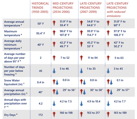
South Bend, Indiana, is starting to see the effects of climate change. In both 2016 and 2018, the city experienced devastating flooding that inundated roads and low-lying areas. According to the 2023 South Bend Climate Risk and Vulnerability Assessment, extreme heat days have steadily been increasing—with the average number of days above 95 degrees Fahrenheit projected to increase by at least 5 and at most 50 by mid-century. Most recently, though, wildfire smoke from hundreds of miles away quite literally turned the sky a different color, setting an eerie backdrop for South Bend residents struggling with respiratory issues and concern for the future of the air they breathe. Wildfire smoke and its visible threat highlighted other concerns: vehicle emissions on hot, sunny days increasing ozone levels and industrial processes releasing harmful particulate matter.
The City of South Bend’s Department of Innovation and Technology and Office of Sustainability, whose missions involve improving residents’ access to technology and mobilizing residents to the climate emergency, became increasingly interested in initiating an environmental health campaign. The problem? City officials lacked real-time, hyperlocal data on air quality to inform public health interventions. Levels of primary pollutants, such as ozone and fine particulate matter, can vary substantially even within a city. This fact poses challenges for cities like South Bend, that rely on air quality readings from one state-owned regional environmental sensor. When identifying locations for cooling centers, for example, there are limited data to identify where extreme heat persists. Schools on one side of town might experience poorer air quality than those on the other on any given day and decide to postpone outdoor recess accordingly.
A new City campaign, called Sense South Bend, would accomplish three main goals:
- • increase the collection of high-quality environmental data;
- • inform the public on the availability of these data and actions to take during different air-quality levels;
- • inform local public health and climate change interventions.
Alex Bazán, South Bend’s Director of Sustainability, says of the initiative “SenseSB provides on-the-ground data that will allow the City to develop policies and programming that equitably serve community members. It has provided opportunities to engage with residents and community partners to discuss air quality, climate change, and how as a community we can work together to improve quality of life.”
To obtain 24-hour air-quality readings at the neighborhood level, the City of South Bend partnered with TELLUS Networked Sensor Solutions. TELLUS’ wireless environmental sensors, when deployed, can measure over nine pollutants and related metrics. Analysis of these long-term data on particulate matter, ozone, carbon monoxide, ambient temperature, and more will allow City of South Bend officials to determine priority geographies within city limits for public programming and infrastructure to address poor air quality and associated health concerns, such as asthma and heart disease. South Bend deployed 22 sensors on city-owned assets, across city limits, over the course of Spring 2024.
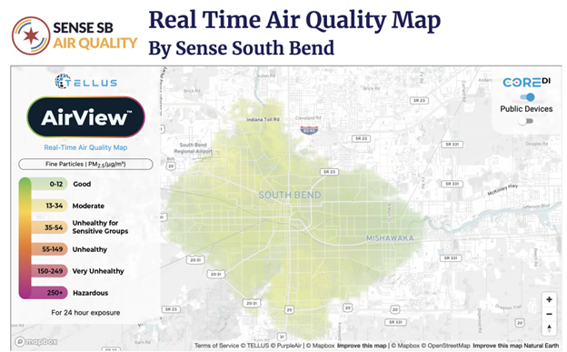
Perhaps most relevant to South Bend’s ultimate goal of providing easily digestible and high-quality air-quality readings to residents, however, is TELLUS’ AirView model, which reflects a real-time interpolation of sensors. The more sensors that are deployed, the better the interpolation. The end result is a color-coded map of city air quality, ranging from healthy to hazardous.
Once South Bend obtained more accurate, geographically focused data, they needed a plan to make air-quality data accessible to the public. They also wanted accompanying guidance on actions to take during air-quality emergencies. Which groups are particularly vulnerable to poor air quality? What are easy actions to reduce air pollution? Are there thresholds for joining in outdoor activities during poor air-quality events? These remained complex questions with ambiguous answers.
The City of South Bend partnered with the Midwest Big Data Innovation Hub (MBDH) through its Community Development and Engagement Program to host a Graduate Environmental Health Fellow, who, over the course of the Spring 2024 Semester, gained learning experience in research, community engagement, and science communication while helping to build out the City of South Bend’s environmental sensing initiative, aptly named Sense South Bend: Air Quality.
Francie Fink, a Master of Public Affairs candidate at the University of Wisconsin–Madison concentrating in Energy Analysis and Policy, was onboarded as the City’s Environmental Health Fellow. From January through May 2024, she conducted research that ultimately informed the creation of a public-facing webpage and accompanying knowledge-based article, social media education campaign for air quality, and supplemental outreach materials for the Sense South Bend: Air Quality initiative.
“Working with the City of South Bend in this role was an incredible experience,” said Fink, “In March, I presented on Sense South Bend to the city’s Environmental Research Coalition, a group formed to strengthen the connection between community-based scientific research and local government. They were interested in how my research complemented ongoing City efforts.”
The MBDH also supported the professional development of Barbara Dale, Project Manager in South Bend’s Office of Sustainability. Barbara attended the Health Effects Institute’s Spring Conference and brought back important insights, which were incorporated into City messaging around air quality. An important one? Often, groups most vulnerable to poor air quality, such as communities living near highways and outdoor workers, don’t necessarily consider themselves sensitive.
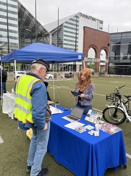

Pictured Left: Francie Fink, Environmental Health Fellow, tables for Sense South Bend at South Bend area’s Bike to Work Week in May 2024.
Pictured Right: Barbara Dale, Project Manager in South Bend’s Office of Sustainability, attends and represents South Bend at the Health Effect Institute’s Spring Conference in Philadelphia in April 2024.
The initiative’s webpage hosts the AirView map with the Environmental Health Fellow’s findings and recommended guidance based on the following air-quality levels: good to moderate, unhealthy, very unhealthy, and hazardous. The guidance outlines sensitive groups and checks on physical activity. For instance, for residents in orange zones on the map, the air quality is unhealthy and sensitive groups, such as those with heart/lung disease and pregnant women, should make outdoor activities short and easy, monitoring symptoms for shortness of breath and heart palpitations.
Sense South Bend: Air Quality will lay the foundation for additional environmental sensing initiatives in South Bend, like Sense South Bend: Water Quality and Sense South Bend: Mobility. Already, residents have interacted with the webpage and social media posts, sharing notices of days with poor air quality and engaging in discussion around the sources of air pollution. Some residents have even expressed interest in purchasing their own TELLUS air sensor, to help improve the network of publicly available sensors.
“As climate change intensifies the challenges of poor air quality and severe heat, real-time data from sensors across the community will help us to better serve our residents,” says Patrick McGuire, Technology Equity Manager for the City of South Bend. “We can empower residents to take informed precautions for their health and drive data-driven solutions for a more resilient city.”
Get Involved/Learn More
To learn more about the Sense South Bend: Air Quality initiative, visit https://southbendin.gov/air-quality/. For more information on the Air Quality Index and related health concerns, visit AirNow.gov at https://www.airnow.gov/air-quality-and-health/. If you are interested in contributing to the network of TELLUS environmental sensors by deploying your own device and making it publicly available, visit https://www.tellusensors.com/products/.
Contact the Midwest Big Data Innovation Hub if you’re aware of other people or projects we should profile here, or to participate in any of our community-led Priority Areas. The Midwest Big Data Innovation Hub is an NSF-funded partnership of the University of Illinois at Urbana-Champaign, Indiana University, Iowa State University, the University of Michigan, the University of Minnesota, and the University of North Dakota, and is focused on developing collaborations in the 12-state Midwest region. Learn more about the national NSF Big Data Hubs community.
